Freeport City Map
[ Launch the Freeport
City Map ] [Go to
the Freeport Map Tutorial]
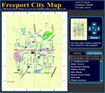 Freeport covers many square miles and you'll need a map to get around. This
interactive, digital map will come in handy for finding just about everything
in town. You'll need it to locate the police station and the location of any
fires that might break out.
Freeport covers many square miles and you'll need a map to get around. This
interactive, digital map will come in handy for finding just about everything
in town. You'll need it to locate the police station and the location of any
fires that might break out.
How to Use the Map, Freeport Directory and Cross Directory
A portion of the text below was used with permission from Melvin Mencher.
Mencher, Melvin. Workbook for use with News Reporting Simulation. Boston: McGraw
Hill. viii.
1. You may be told that Anne Downey was injured in a fire. Because addresses
are an essential part of a person's identification, you would consult the Freeport
City Map Directory to find her address 165 Vincent St.
2. Your instructor may give you an exercise about a fire located at State Highway
166 and U.S. 81 and ask you how you would handle the assignment if you were
on a deadline. You would, of course call the fire department for information.
You would also want an on-the-scene account if it were a big fire. Because you
could not take the time to go there, you might call the people who live nearby.
Using the Freeport City Map and Cross Directory, you can locate someone to call.
Consulting the map, you would find the intersection is at the southern edge
of town and that Hunter Avenue is the city continuation of U.S. 81. The map
shows that a place known as Three Corners Junction is in the vicinity.
You would use the Freeport Cross Directory to find an address on Hunter Avenue.
The first entry, 4700 Hunter Ave., lists a Three Corners Cafe. You would call
the Cafe to find someone who can describe the fire for you while another reporter
and a photographer are on the way.