Collect Locations Using Google Doc Map Widget
Back in June 2009 we mentioned that you could use Google Docs' spreadsheets to collect data via a Web form. This can be taken one step further. Namely, the form/spreadsheet can be used as a mechanism to directly collect and chart map data.
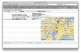
Inside each Google spreadsheet is a "widget" that will map the datapoints collected from contributors via a form. That map can be embedded into any Web page (with some simple HTML code and Javascript provided by the widget). This might allow students to research locations (e.g. historical sites or military installations) and easily input those data into a spreadsheet via the Web form. A short time later, those locations automatically appear on the centralized map, which can be embedded into a course Web site or wiki.

Here is an example for you to try. This system will map great places to eat in NYC.
Visit this form where you can add a restaurant to the list.
The form fills in a spreadsheet and a map--both of which can be viewed here:
http://spreadsheets.google.com/pub?key=p-BdijJprln30-QIuO_jRSg
The map that you create using the spreadsheet and form can be embedded into any web page (e.g. wikispaces or courseworks).


